Mount Douglas Project
Overview
The Mount Douglas project is located within the Rum Jungle Uranium Field, approximately 50 kilometres east of the township of Adelaide River and approximately 130 kilometres southeast of Darwin in Northern Territory. The project consists of two granted exploration licences EL 31451 (Mount Douglas) and EL 33075 (Ban Ban Springs) that covers a combined area of 588 square kilometres and one exploration licence application EL 32038 (Mary River).
Prospectivity
The Mount Douglas project is located on the eastern flank of the Rum Jungle Mineral Field (RJMF) which was the first major uranium mining and processing centre in Australia. There are several uranium mineral occurrences in the Mount Douglas region, most of which are interpreted to be unconformity-style mineralisation which is the principal target in the project area.
Four specific exploration targeting models will be applied in the exploration for principally uranium, and other commodities such as gold, tin and base metals. These models include:
- Unconformity-style uranium mineralisation associated with the Kombolgie Sandstone unconformity;
- Structurally-controlled mineralisation associated with fold hinges and faults within the Paleoproterozoic metasediments and around the margins of the Cullen Intrusive Complex;
- Mineralisation associated with contact thermal metamorphism around the margins of the Minglo Granite and Margaret Granite, the Minglo Granite particularly of interest for uranium; and lastly
- Mineralisation associated with specific geological formations regionally known to host uranium and/or gold deposits.
Geology
The Mount Douglas project is situated on the eastern margin of the Rum Jungle Mineral Field within the Central Domain of the Pine Creek Orogen in the North Australian Craton. The Central Domain is comprised of greenschist-facies Paleoproterozoic metasedimentary rocks (2,021-1,861 Ma) intruded by syn- and post-tectonic granitoid plutons and minor mafic rocks.
The Mount Douglas project area is largely covered by Paleoproterozoic sediments of the Mount Partridge Group (2,050 to 2,000 Ma) in the east, overlain by the South Alligator Group (2,000 to 1,860 Ma), in turn overlain by sediments of the Finniss River Group (1,860 to 1,850 Ma) to the west. The sediments comprise granite intrusions of the Cullen Batholith (1,850 to 1,800 Ma), (Figure 1).
The Mount Douglas project area contains a fault-bound outlier of Middle Proterozoic arenite, considered an equivalent of settings associated with unconformity-style uranium mineralisation elsewhere in the Pine Creek Orogen. The project area features a 20 kilometre strike length of favourable geology (unconformity at the base of the Kombolgie Basal Conglomerate), uranium anomalism in surface samples and several areas of elevated radiometric responses that require further investigation. Up to 1,089ppm U has been returned from surface sampling of a haematitic ironstone band in the area.
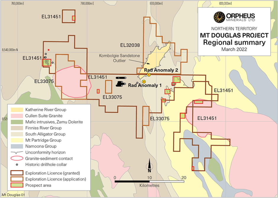
Figure 1: Mount Douglas project regional geology, with historic drill hole locations and identified prospect areas
Exploration
Exploration activities proposed by Orpheus include programs designed to test existing targets and define the unconformity, the granite aureoles and areas of structural complexity in more detail. Exploration methods likely to be employed include compilation of historical data into a company database, re-process public file EM data, systematically ground truth radiometric and surface anomalism and conduct prospect scale geological mapping and detailed surface/costean geochemical programs. Trenching or costeaning across Radiometric Anomaly 1 and 2 is proposed, followed by diamond or RC drilling to provide further geological information and uranium grades at depth.

URANIUM PROJECTS
South Australia
South Australia
South Australia
Northern Territory
Western Australia
