Radium Hill South Project
Overview
The Radium Hill South prospect comprises one exploration licence EL 6960 that covers an area of 797 square kilometres, located approximately 20 kilometres south of the historic Radium Hill Uranium Field in South Australia, (Figure 1). The EL was awarded to Orpheus’ via a competitive application process by the Government of South Australia. EL 6960 is located directly north of tenure recently awarded to Boss Energy Ltd (ASX: BOE).
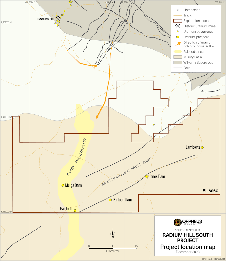
Figure 1: Radium Hill South project location and uranium occurrences, highlighting the five uranium occurrences located within the competitive licence application that was granted to Orpheus, located 20 km south of the Radium Hill Uranium Field
Prospectivity
The Radium Hill South project is considered highly prospective for roll-front and tabular-style, sedimentary-hosted uranium mineralisation associated with Tertiary palaeochannels. The region is situated approximately 20 kilometres south of the radiogenic region of the Radium Hill Uranium Field (Figure 1) and 100 km southeast of the Crocker Well Uranium Field host to the hard rock uranium deposits and further to the north, the Honeymoon and Goulds Dam sediment-hosted Tertiary palaeochannel uranium deposits.
The mineralisation model at the Radium Hill South project comprises both sediment-hosted and silcrete-hosted uranium mineralisation within Neogene sediments including the Geera Clay, and Paleogene channel sands including the Warina Sand of the Olary Palaeovalley System known to host uranium mineralisation at the uranium occurrences; Mulga Dam, Gairloch, Kinloch Dam, Jones Dam and Lamberts, at depths of approximately 80m-110m located within, sedimentary and structurally-controlled palaeochannel features.
Previous explorer, Mega Hindmarsh Pty Ltd (2005-2014) analysis of its drillhole geophysical logs revealed the presence of previously undetected, north-south trending sedimentary channels and deltaic sequences, which overlie reducing carbonaceous mudstone. These sedimentary facies were found to be very anomalous in uranium, yielding significant gamma log intercept thicknesses of up to 10.7m at Jones Dam and 8m at Gairloch Dam. The channels were interpreted to be at least 5 km in length, and Mega Hindmarsh Pty Ltd was confident that they offer an excellent target for future investigation.
Historic significant intercepts from the existing five uranium occurrences located within EL 6960 Radium Hill South project and reported by Mega Hindmarsh Pty Ltd[1] include:
- Mulga Dam
- 1,350 cps at 95m depth in fluviatile, Lower Miocene carbonaceous clays.
- Gairloch
- 2,266 cps at 104.1m at the contact between the base of the channel and underlying black carbonaceous clay, assay grade obtained by analysis of the drill cuttings from this interval was 400 ppm U3O8 over 1.9m from 103.8m.
- Kinloch Dam
- 507 ppm U3O8 over 3m from 105m in M64 in sand below a silcrete layer.
- 23m averaging 129 cps of radiometrically anomalous sand and clay.
- Jones Dam
- 401 ppm U3O8 over 2m from 86m in drillhole 06RMCD040 in a strongly anomalous zone over 5.1m, within steely grey sand;
- 7m of radiometrically anomalous sand from 82.7m in drill hole 06RMCD048, associated with peak gamma values of 1,041cps, or 263 ppm eU3O8;
- 6m of radiometrically anomalous sand from 98.9m in drill hole 06RMCD034, with a gamma maximum of 1,056 cps at 265 ppm eU3O8;
- 4m of radiometrically anomalous oxidised sand and reduced sand with wood fragments in drill hole 07RMCD026 from 91.5m, includes 0.25m at 382 ppm eU3O8.
- Lamberts
- Best intercept was 0.7m at 0.073% U3O8 at 102.2 m in drillhole WE1.
Mega Hindmarsh Pty Ltd worked with CSIRO in 2010 developing the sequence stratigraphy, palynology, spectral mineralogy, geochemistry and structure to provide vectors to channels of uranium transport and to depositional sites for drilling by understanding the sedimentation architecture of the region through implementing the SEDSIM flow and sedimentation program (Figure 1). The results provide excellent indication of alternating lignite, sand depositional environments that warrant further investigation.
Results presented as extracted from the CSIRO report[2] includes the following:
The implications for uranium enrichment are:
- If uranium-bearing fluids were carried in the river water at all times, then all fluvial sediments may have been favourable for uranium enrichment.
- The reductant in the area may have been organic clays or lignite or carried organics in the fluvial channels.
- The interface between clay/lignite and fluvial sediment may provide a potential trap site.
- The SEDSIM model shows potential for trap sites throughout the project area because of the migrating nature of the alluvial fan.
- The trap sites also act if lignite is the source of uranium.
- Any sediment that was eroded and may have had a uranium accumulation would have been transported towards the southern areas onto the floodplain.
Importantly, this study was completed in 2010, at a time when Mega Hindmarsh Pty Ltd changed exploration focus from uranium to iron ore (magnetite) of the Braemar Iron Formation. Orpheus intends to revisit the study to review sedimentation anomalies and to further define regional features to channel scale through geophysical methods (passive seismic, ground gravity, electrical methods) to assist with identifying roll-front environments and locating drillholes.
[1] Source: Uranium grades extracted from Open File Report, Envelope 11421 compiled by Mega Hindmarsh Pty Ltd during the period 2005 to 2014, Cronje Dam Project.
[2] Johns, S., Schmid, S., Dyt, C., Annetts, D., Fisher, L., Robinson, J., & Hill, J. (2010). JSU – Mega Hindmarsh Pty Ltd, Cronje Dam Project, Final Report, Envelope 11421. CSIRO.
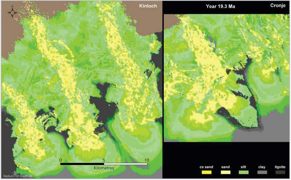
Figure 2: Mega Hindmarsh Pty Ltd / CSIRO plan image from the SEDSIM flow and sedimentation program showing alluvial fan deposition, cutting deep into underlying sediments forming unconformities, source CSIRO, (Johns, et al., 2010)
Geology
The Radium Hill South project lies approximately 20 km south of the Radium Hill Uranium Field that comprises Willyama Supergroup basement rocks. Epigenetic-style uranium mineralisation occurs in the form of davidite as vein ‘lodes’ within intensely altered shear zones hosted by high metamorphic grade quartzo-feldspathic paragneiss and amphibolite over a strike length of >7 km which has historically been mined to a depth of 290m on nine levels over a strike length of 1,400m[1]. Drainage patterns have formed in a southerly direction toward the Murray-Darling Basin as part of the Olary Palaeochannel System. Sediment-hosted uranium mineralisation is believed to have formed from oxidised groundwaters draining from the Willyama Supergroup basement rocks from the Radium Hill Region. The Tertiary sediments comprise carbonaceous clays and sands suitable for uranium to form sedimentary and/or tabular redox fronts.
Reducing host rocks within the project area where uranium mineralisation has been identified include units of the Renmark Group:
- Lower Miocene carbonaceous clays with associated sands of the Geera Clay (equivalent unit to the Namba Formation of the Frome Embayment) within palaeodrainage features of the Olary Palaeovalley System along the northern margin of the Murray-Darling Basin in the vicinity of the Anabama-Redan Fault Zone (Figure 2).
- Lower Eocene sands remain a uranium target to be further explored within palaeochannel features and comprises the Upper Sand and Lower Sand units of the Warina Sand (equivalent unit to the Eyre Formation of the Frome Embayment) (Figure 2).
[1] Source: https://minerals.sarig.sa.gov.au/MineralDepositDetails.aspx?DEPOSIT_NO=962
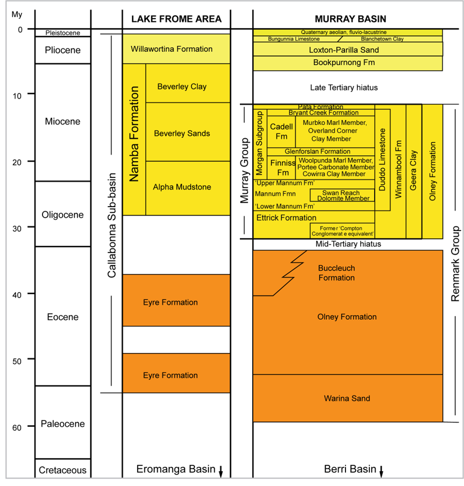
Figure 3: Cenozoic stratigraphy of the Lake Frome area and Murray-Darling Basin. Modified after Cowley and Barnett (2007), Skirrow (2009) and Whitehouse et al. (1999)[1].
Uranium enriched source rocks proximal and probable to the project area include:
- Hydrothermal vein uranium mineralisation within gneisses of the Willyama Supergroup, where uranium minerals are present as structurally-controlled uraniferous lodes within foliated migmatitic gneiss such as Radium Hill Uranium Field and the Victoria Hut uranium occurrence;
- Radiogenic granites from the Olary Domain where uranium minerals are present within veins and breccia veins within host Mesoproterozoic granites such as Crocker Well and Mount Victoria uranium deposits;
- Ordovician granites intruding the Adelaidean metasediments where uranium has been identified proximal to the granite margins of the Anabama Granite pluton and the Cromwell Granite, such as the Dark Horse uranium occurrence (Figure 3);
- Influence from hydrothermal, basement-derived, fault-localised, fluids during uranium precipitation in the sediments proximal to the Anabama-Redan Fault Zone/Escarpment.

Figure 4: Block diagram summarising the geological components where the source of uranium is the Ordovician granites and Precambrian bedrock, eroding south into the Murray-Darling Basin. Sandstone-hosted uranium deposits are formed when oxidised uranium is precipitated from fluid flowing in permeable sandstones in the Southern Curnamona Province (after Roach, 2012).
Exploration
Orpheus’ exploration objective is to target sedimentary-hosted roll-front and/or tabular-style uranium mineralisation located within paleochannel drainage features and along the buried escarpment of the northeast-southwest trending Anabama-Redan Fault.
- Orpheus will acquire passive seismic, ground gravity and electrical method surveys to constrain paleochannel margins, map structures, determine the effects of faulting, and basement topography.
- Drilling of high priority targets at the existing five uranium occurrences located within EL 6960 Radium Hill South project; Mulga Dam, Gairloch, Kinloch Dam, Jones Dam and Lamberts.
Orpheus has commenced compiling existing datasets of the five uranium prospects: Mulga Dam, Gairloch, Kinloch Dam, Jones Dam and Lamberts, in preparation toward drilling.

URANIUM PROJECTS
South Australia
South Australia
South Australia
Northern Territory
